Fresh 'danger to life' warnings have been issued as 80mph gales from Storm Jocelyn is expected to hit the UK tomorrow.
A map shows how the latest storm is expected to batter large parts of the country, leading to more disruption to travel and utilities.
The strongest winds are expected to affect western and northern Scotland from Tuesday evening, while yellow warnings for heavy rain have also been put in place for much of England.
The warnings comes less than 24 hours after Storm Isha left a trail of devastation in its wake after 100mph winds saw cars crushed under falling trees, roofs ripped off buildings and left an 84-year-old man dead.
Thousands of people have been left without power as the storm brought disruption to the electricity and transport networks across the UK.
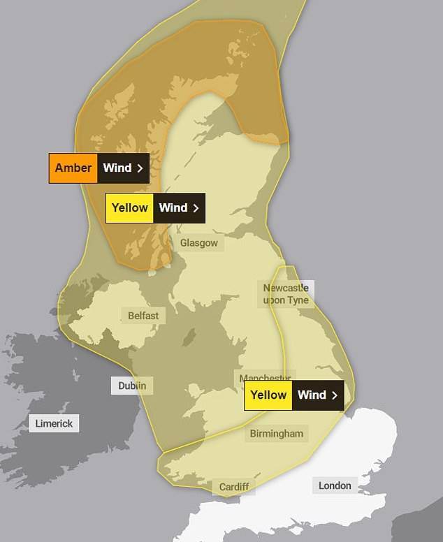
A Met Office map shows how the latest storm is expected to batter large parts of the country, leading to more disruption to travel and utilities.
Fallen trees have affected transport with Traffic Scotland reporting stretches of the M9 and M74 were among roads closed throughout the night, while the A1 southbound was closed at Thorntonloch due to an overturned lorry.
In Scotland, an 84-year-old man was killed after a Hyundai car was crushed by a tree on the A905, Beancross Road in Grangemouth at around 11.45pm last night. Police said he was pronounced dead at the scene, while the other occupants of the vehicle were not injured.
In Appleby, haunting sirens wailed across the Cumbria town as flood waters surged through the streets.
High winds forced the closure of the Tay Road Bridge, M48 Severn Bridge and the A66 in Durham and Cumbria between the A1(M) and the M6, while the Humber Bridge, A19 Tees Flyover and A628 Woodhead Pass in Derbyshire were among stretches closed to high-sided vehicles.
After a 'difficult night' Network Rail has cancelled all passenger and freight trains across the country until they can inspect rail routes and repair the damage of the storm.